- Home
- County maps
- Texas
Texas County Map
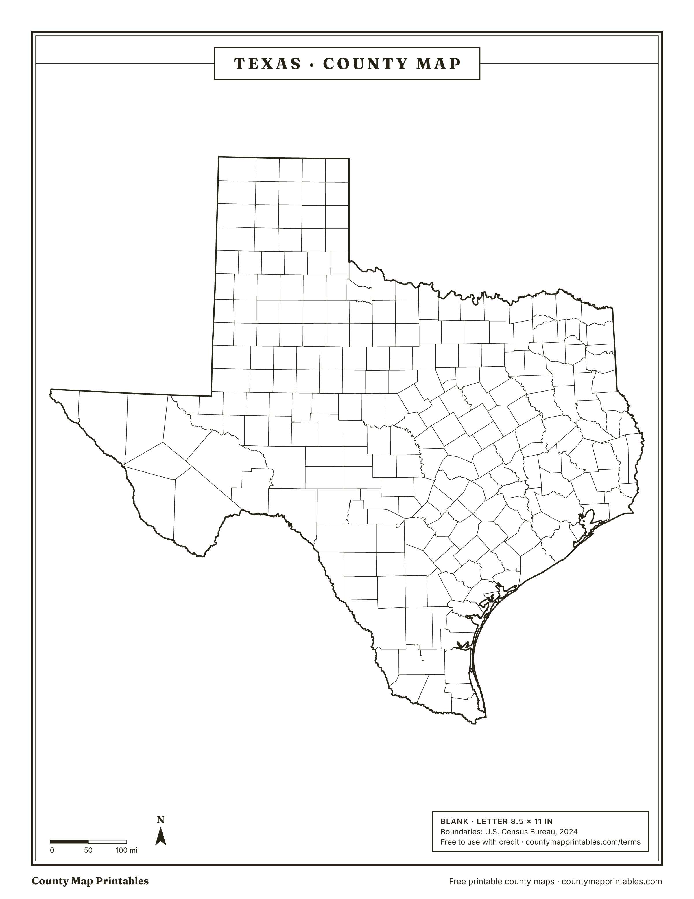
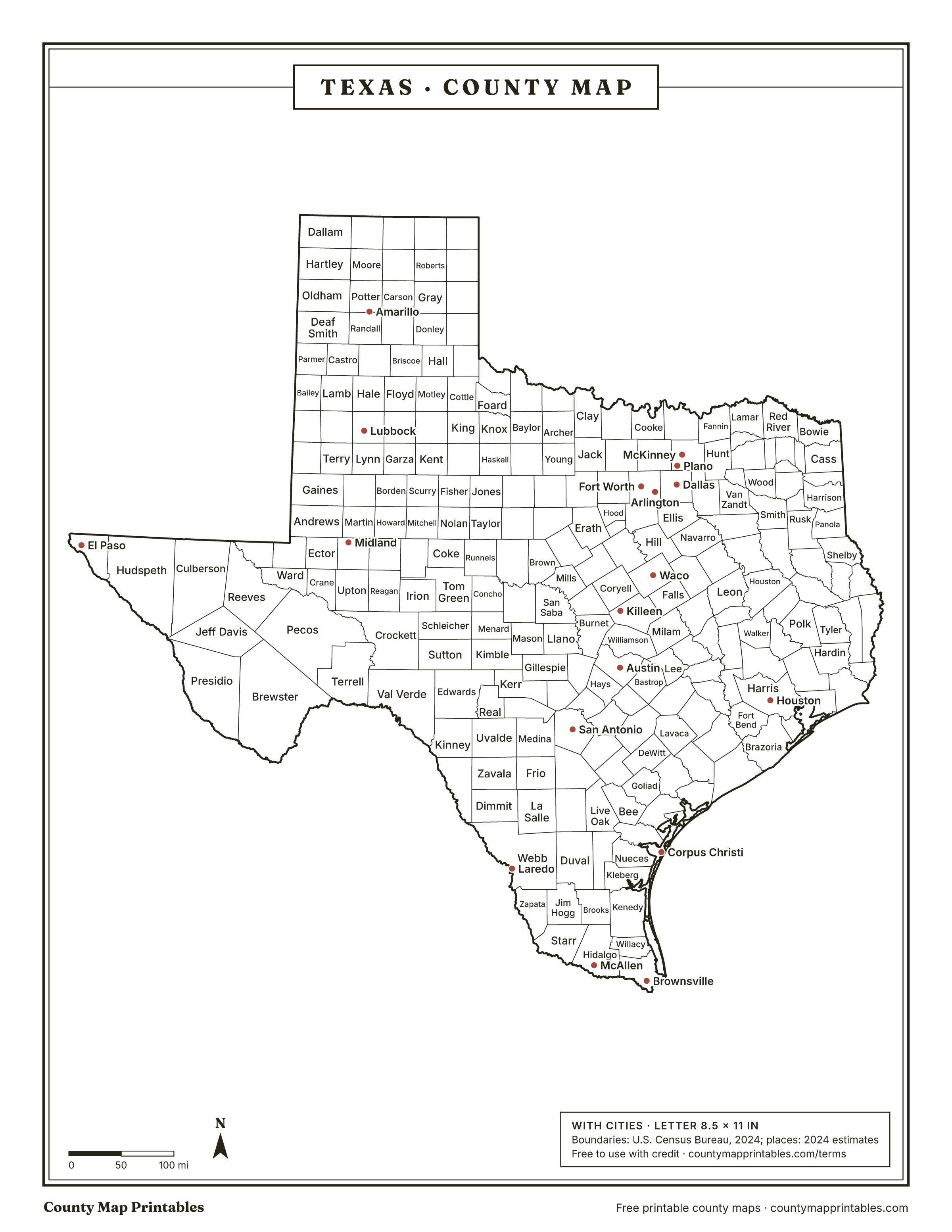
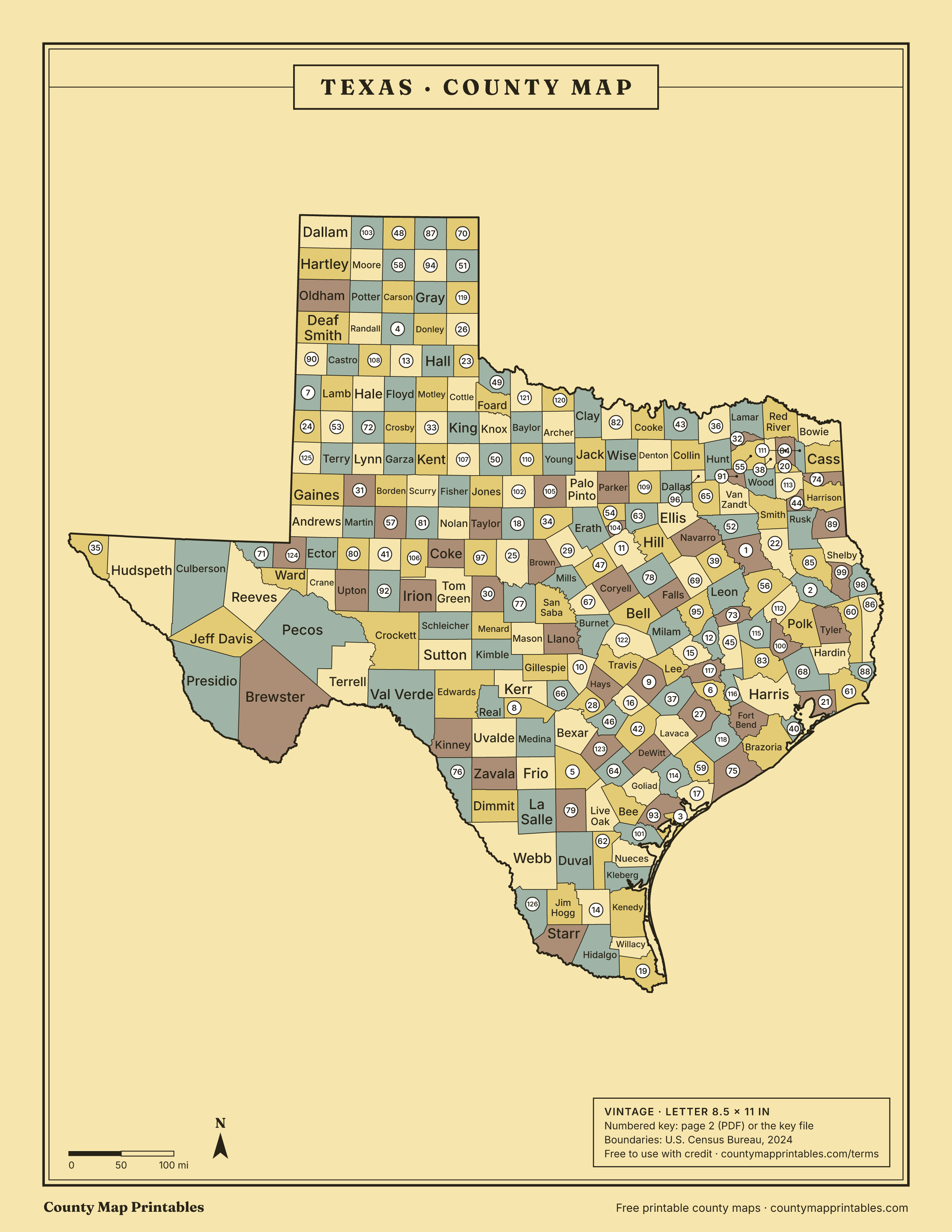
Texas has 254 counties, more than any other state. Brewster is the largest by land area, Rockwall the smallest, and Harris the most populous. Print this Texas (TX) county map blank or labeled, or look up any county by name below.
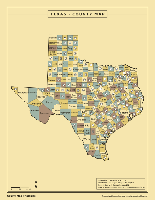
Map of Texas counties
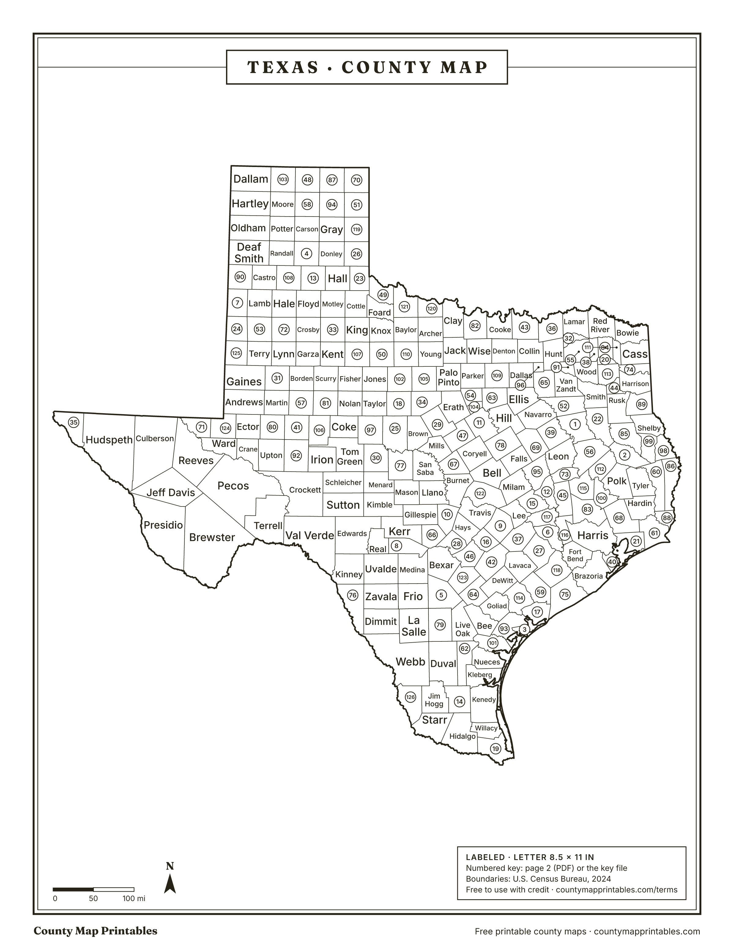
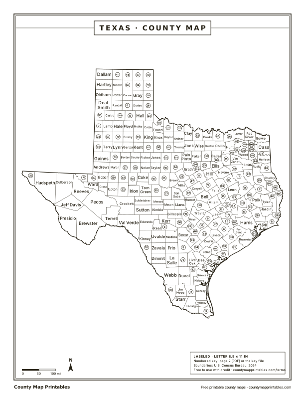
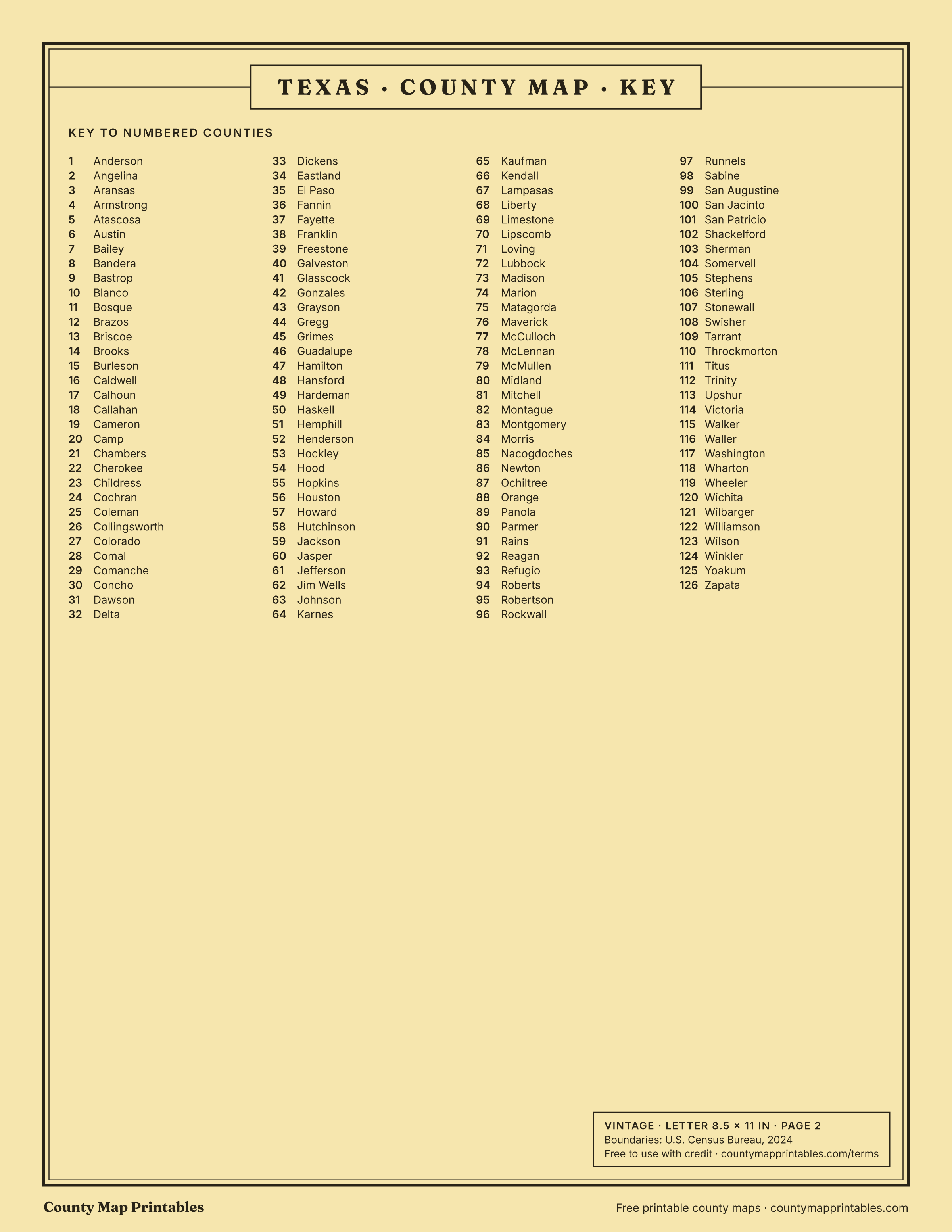
Free to use with credit · Licence · Numbered counties are named in the key below and on page 2 of the PDF.
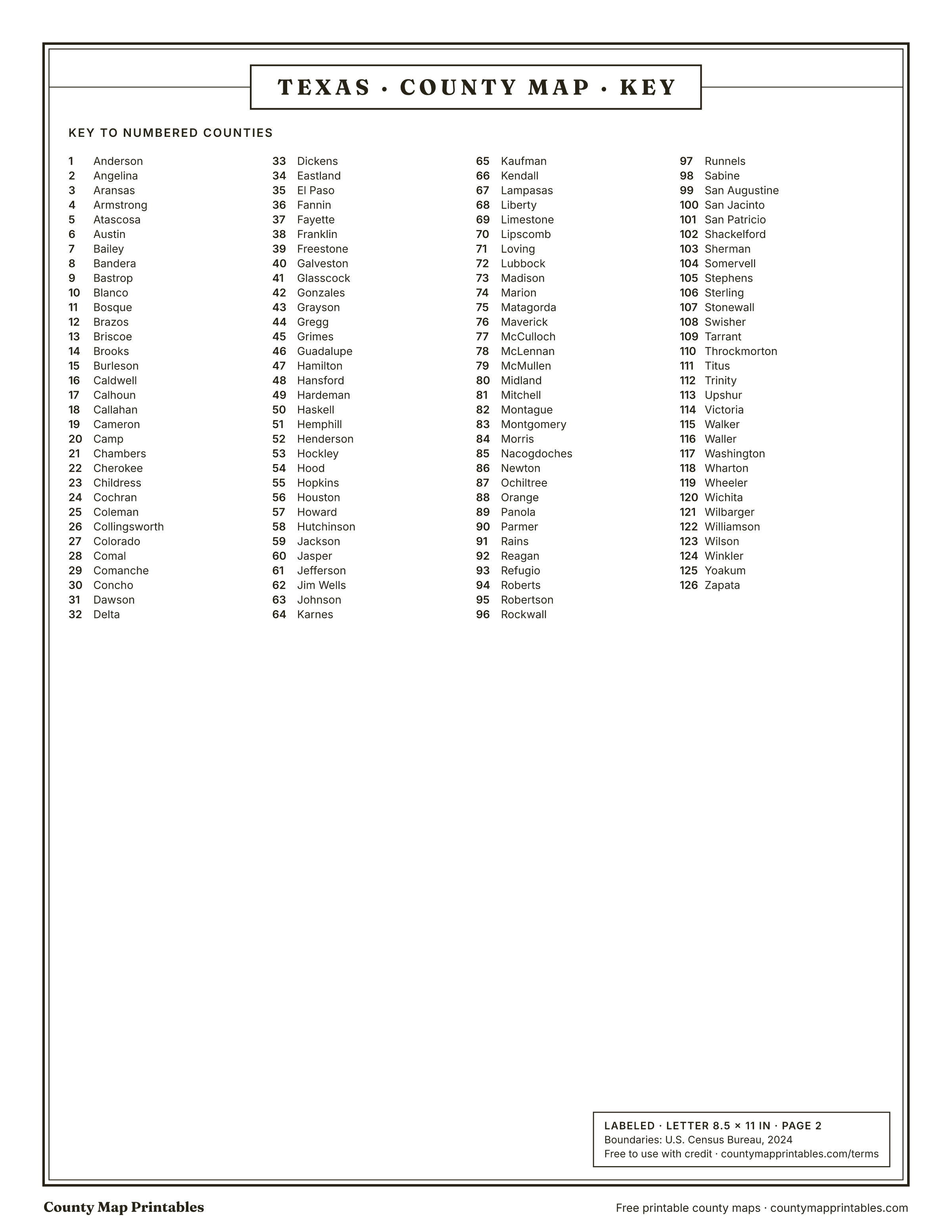
Key to the 126 numbered counties (Labeled and Vintage maps)
- Anderson
- Angelina
- Aransas
- Armstrong
- Atascosa
- Austin
- Bailey
- Bandera
- Bastrop
- Blanco
- Bosque
- Brazos
- Briscoe
- Brooks
- Burleson
- Caldwell
- Calhoun
- Callahan
- Cameron
- Camp
- Chambers
- Cherokee
- Childress
- Cochran
- Coleman
- Collingsworth
- Colorado
- Comal
- Comanche
- Concho
- Dawson
- Delta
- Dickens
- Eastland
- El Paso
- Fannin
- Fayette
- Franklin
- Freestone
- Galveston
- Glasscock
- Gonzales
- Grayson
- Gregg
- Grimes
- Guadalupe
- Hamilton
- Hansford
- Hardeman
- Haskell
- Hemphill
- Henderson
- Hockley
- Hood
- Hopkins
- Houston
- Howard
- Hutchinson
- Jackson
- Jasper
- Jefferson
- Jim Wells
- Johnson
- Karnes
- Kaufman
- Kendall
- Lampasas
- Liberty
- Limestone
- Lipscomb
- Loving
- Lubbock
- Madison
- Marion
- Matagorda
- Maverick
- McCulloch
- McLennan
- McMullen
- Midland
- Mitchell
- Montague
- Montgomery
- Morris
- Nacogdoches
- Newton
- Ochiltree
- Orange
- Panola
- Parmer
- Rains
- Reagan
- Refugio
- Roberts
- Robertson
- Rockwall
- Runnels
- Sabine
- San Augustine
- San Jacinto
- San Patricio
- Shackelford
- Sherman
- Somervell
- Stephens
- Sterling
- Stonewall
- Swisher
- Tarrant
- Throckmorton
- Titus
- Trinity
- Upshur
- Victoria
- Walker
- Waller
- Washington
- Wharton
- Wheeler
- Wichita
- Wilbarger
- Williamson
- Wilson
- Winkler
- Yoakum
- Zapata
Texas counties at a glance
Download every version
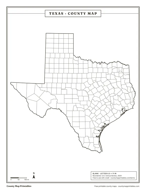 BlankTabloid 11×17 PDF
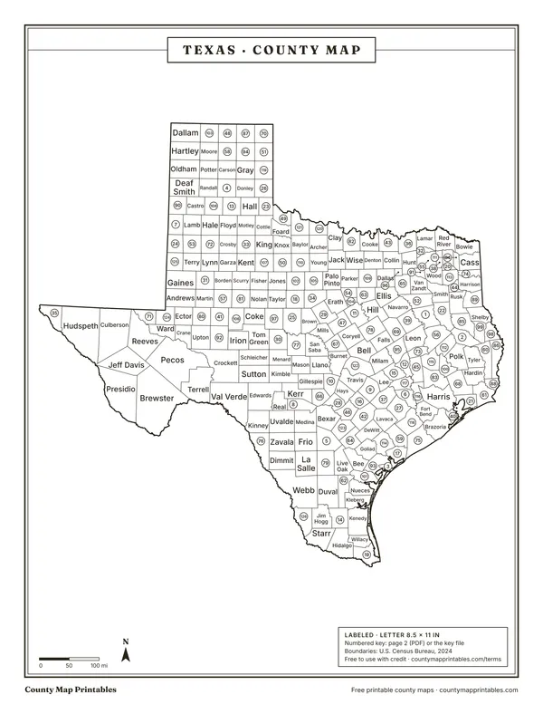 LabeledTabloid 11×17 PDFNumbered key PNG
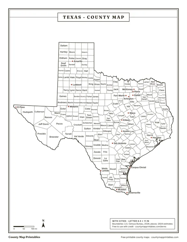 With citiesTabloid 11×17 PDF
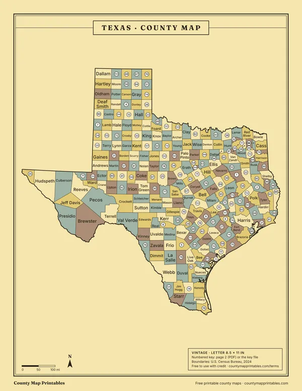 VintageTabloid 11×17 PDFNumbered key PNG
Name, FIPS, land area (sq mi, km²), population, vintage · all 254 rows
List of counties in Texas
| Borders | ||||
|---|---|---|---|---|
| Harris County | 48201 | 1,707 | 5,009,302 | Brazoria, Chambers, Fort Bend, Galveston, Liberty, Montgomery, Waller |
| Dallas County | 48113 | 873 | 2,656,028 | Collin, Denton, Ellis, Kaufman, Rockwall, Tarrant |
| Tarrant County | 48439 | 865 | 2,230,708 | Dallas, Denton, Ellis, Johnson, Parker, Wise |
| Bexar County | 48029 | 1,240 | 2,127,737 | Atascosa, Bandera, Comal, Guadalupe, Kendall, Medina, Wilson |
| Travis County | 48453 | 994 | 1,363,767 | Bastrop, Blanco, Burnet, Caldwell, Hays, Williamson |
| Collin County | 48085 | 841 | 1,254,658 | Dallas, Denton, Fannin, Grayson, Hunt, Rockwall |
| Denton County | 48121 | 879 | 1,045,120 | Collin, Cooke, Dallas, Grayson, Tarrant, Wise |
| Fort Bend County | 48157 | 862 | 958,434 | Austin, Brazoria, Harris, Waller, Wharton |
| Hidalgo County | 48215 | 1,571 | 914,820 | Brooks, Cameron, Kenedy, Starr, Willacy |
| El Paso County | 48141 | 1,014 | 875,784 | Doña Ana, NM, Hudspeth, Otero, NM |
| Montgomery County | 48339 | 1,042 | 749,613 | Grimes, Harris, Liberty, San Jacinto, Walker, Waller |
| Williamson County | 48491 | 1,116 | 727,480 | Bastrop, Bell, Burnet, Lee, Milam, Travis |
| Cameron County | 48061 | 892 | 431,874 | Hidalgo, Willacy |
| Brazoria County | 48039 | 1,363 | 413,224 | Fort Bend, Galveston, Harris, Matagorda, Wharton |
| Bell County | 48027 | 1,054 | 399,578 | Burnet, Coryell, Falls, Lampasas, McLennan, Milam, Williamson |
| Galveston County | 48167 | 379 | 367,407 | Brazoria, Chambers, Harris |
| Nueces County | 48355 | 839 | 353,125 | Aransas, Jim Wells, Kleberg, San Patricio |
| Lubbock County | 48303 | 896 | 327,394 | Crosby, Floyd, Garza, Hale, Hockley, Lamb, Lynn, Terry |
| Hays County | 48209 | 677 | 292,029 | Blanco, Caldwell, Comal, Guadalupe, Travis |
| Webb County | 48479 | 3,362 | 272,823 | Dimmit, Duval, Jim Hogg, La Salle, Maverick, McMullen, Zapata |
| McLennan County | 48309 | 1,037 | 270,358 | Bell, Bosque, Coryell, Falls, Hill, Limestone |
| Jefferson County | 48245 | 877 | 253,948 | Cameron, LA, Chambers, Hardin, Liberty, Orange |
| Brazos County | 48041 | 586 | 249,624 | Burleson, Grimes, Leon, Madison, Robertson, Washington |
| Smith County | 48423 | 922 | 249,091 | Cherokee, Gregg, Henderson, Rusk, Upshur, Van Zandt, Wood |
| Ellis County | 48139 | 936 | 232,387 | Dallas, Henderson, Hill, Johnson, Kaufman, Navarro, Tarrant |
| Johnson County | 48251 | 725 | 210,547 | Bosque, Ellis, Hill, Hood, Parker, Somervell, Tarrant |
| Comal County | 48091 | 560 | 201,628 | Bexar, Blanco, Guadalupe, Hays, Kendall |
| Kaufman County | 48257 | 781 | 197,829 | Dallas, Ellis, Henderson, Hunt, Rockwall, Van Zandt |
| Guadalupe County | 48187 | 711 | 195,166 | Bexar, Caldwell, Comal, Gonzales, Hays, Wilson |
| Midland County | 48329 | 900 | 183,587 | Andrews, Ector, Glasscock, Martin, Reagan, Upton |
| Parker County | 48367 | 904 | 179,707 | Hood, Jack, Johnson, Palo Pinto, Tarrant, Wise |
| Ector County | 48135 | 898 | 170,022 | Andrews, Crane, Midland, Upton, Ward, Winkler |
| Randall County | 48381 | 913 | 150,547 | Armstrong, Carson, Castro, Deaf Smith, Oldham, Potter, Swisher |
| Grayson County | 48181 | 933 | 150,532 | Bryan, OK, Collin, Cooke, Denton, Fannin, Love, OK, Marshall, OK |
| Taylor County | 48441 | 916 | 148,813 | Callahan, Coleman, Fisher, Jones, Nolan, Runnels |
| Rockwall County | 48397 | 127 | 137,044 | Collin, Dallas, Hunt, Kaufman |
| Wichita County | 48485 | 628 | 129,984 | Archer, Baylor, Clay, Cotton, OK, Tillman, OK, Wilbarger |
| Gregg County | 48183 | 273 | 126,679 | Harrison, Rusk, Smith, Upshur |
| Tom Green County | 48451 | 1,522 | 120,103 | Coke, Concho, Irion, Menard, Reagan, Runnels, Schleicher, Sterling |
| Hunt County | 48231 | 840 | 118,729 | Collin, Delta, Fannin, Hopkins, Kaufman, Rains, Rockwall, Van Zandt |
| Liberty County | 48291 | 1,159 | 115,042 | Chambers, Hardin, Harris, Jefferson, Montgomery, Polk, San Jacinto |
| Bastrop County | 48021 | 888 | 114,931 | Caldwell, Fayette, Lee, Travis, Williamson |
| Potter County | 48375 | 908 | 114,649 | Armstrong, Carson, Deaf Smith, Moore, Oldham, Randall |
| Bowie County | 48037 | 885 | 91,992 | Cass, Little River, AR, McCurtain, OK, Miller, AR, Morris, Red River |
| Victoria County | 48469 | 882 | 91,949 | Calhoun, DeWitt, Goliad, Jackson, Lavaca, Refugio |
| Angelina County | 48005 | 798 | 88,094 | Cherokee, Houston, Jasper, Nacogdoches, Polk, San Augustine, Trinity, Tyler |
| Henderson County | 48213 | 874 | 87,467 | Anderson, Cherokee, Ellis, Freestone, Kaufman, Navarro, Smith, Van Zandt |
| Coryell County | 48099 | 1,052 | 86,370 | Bell, Bosque, Hamilton, Lampasas, McLennan |
| Orange County | 48361 | 334 | 86,115 | Calcasieu, LA, Cameron, LA, Hardin, Jasper, Jefferson, Newton |
| Walker County | 48471 | 784 | 83,722 | Grimes, Houston, Madison, Montgomery, San Jacinto, Trinity |
| Wise County | 48497 | 905 | 81,275 | Cooke, Denton, Jack, Montague, Parker, Tarrant |
| San Patricio County | 48409 | 693 | 71,467 | Aransas, Bee, Jim Wells, Live Oak, Nueces, Refugio |
| Harrison County | 48203 | 900 | 71,370 | Caddo, LA, Gregg, Marion, Panola, Rusk, Upshur |
| Hood County | 48221 | 421 | 69,126 | Erath, Johnson, Palo Pinto, Parker, Somervell |
| Starr County | 48427 | 1,223 | 66,587 | Brooks, Hidalgo, Jim Hogg, Zapata |
| Nacogdoches County | 48347 | 946 | 65,728 | Angelina, Cherokee, Rusk, San Augustine, Shelby |
| Van Zandt County | 48467 | 843 | 65,304 | Henderson, Hunt, Kaufman, Rains, Smith, Wood |
| Waller County | 48473 | 513 | 65,109 | Austin, Fort Bend, Grimes, Harris, Montgomery, Washington |
| Anderson County | 48001 | 1,063 | 59,512 | Cherokee, Freestone, Henderson, Houston, Leon |
| Maverick County | 48323 | 1,280 | 58,829 | Dimmit, Kinney, Uvalde, Webb, Zavala |
| Hardin County | 48199 | 891 | 58,670 | Jasper, Jefferson, Liberty, Orange, Polk, Tyler |
| Navarro County | 48349 | 1,010 | 56,533 | Ellis, Freestone, Henderson, Hill, Limestone |
| Chambers County | 48071 | 597 | 56,179 | Galveston, Harris, Jefferson, Liberty |
| Burnet County | 48053 | 995 | 55,722 | Bell, Blanco, Lampasas, Llano, San Saba, Travis, Williamson |
| Medina County | 48325 | 1,325 | 55,619 | Atascosa, Bandera, Bexar, Frio, Uvalde, Zavala |
| Wilson County | 48493 | 804 | 55,415 | Atascosa, Bexar, Gonzales, Guadalupe, Karnes |
| Polk County | 48373 | 1,057 | 54,258 | Angelina, Hardin, Liberty, San Jacinto, Trinity, Tyler |
| Kerr County | 48265 | 1,103 | 53,900 | Bandera, Edwards, Gillespie, Kendall, Kimble, Real |
| Rusk County | 48401 | 924 | 53,391 | Cherokee, Gregg, Harrison, Nacogdoches, Panola, Shelby, Smith |
| Cherokee County | 48073 | 1,053 | 53,223 | Anderson, Angelina, Henderson, Houston, Nacogdoches, Rusk, Smith |
| Atascosa County | 48013 | 1,220 | 52,783 | Bexar, Frio, Karnes, La Salle, Live Oak, McMullen, Medina, Wilson |
| Caldwell County | 48055 | 545 | 52,430 | Bastrop, Fayette, Gonzales, Guadalupe, Hays, Travis |
| Kendall County | 48259 | 663 | 51,828 | Bandera, Bexar, Blanco, Comal, Gillespie, Kerr |
| Lamar County | 48277 | 907 | 51,249 | Bryan, OK, Choctaw, OK, Delta, Fannin, Red River |
| Wood County | 48499 | 645 | 48,742 | Camp, Franklin, Hopkins, Rains, Smith, Upshur, Van Zandt |
| Val Verde County | 48465 | 3,145 | 47,999 | Crockett, Edwards, Kinney, Sutton, Terrell |
| Erath County | 48143 | 1,083 | 44,496 | Bosque, Comanche, Eastland, Hamilton, Hood, Palo Pinto, Somervell |
| Cooke County | 48097 | 875 | 44,258 | Denton, Grayson, Love, OK, Montague, Wise |
| Upshur County | 48459 | 583 | 44,050 | Camp, Gregg, Harrison, Marion, Morris, Smith, Wood |
| Wharton County | 48481 | 1,086 | 42,035 | Austin, Brazoria, Colorado, Fort Bend, Jackson, Matagorda |
| Jim Wells County | 48249 | 865 | 38,886 | Brooks, Duval, Kleberg, Live Oak, Nueces, San Patricio |
| Hopkins County | 48223 | 767 | 38,784 | Delta, Franklin, Hunt, Rains, Wood |
| Hill County | 48217 | 959 | 38,771 | Bosque, Ellis, Johnson, Limestone, McLennan, Navarro |
| Fannin County | 48147 | 878 | 38,650 | Bryan, OK, Collin, Delta, Grayson, Hunt, Lamar |
| Brown County | 48049 | 945 | 38,631 | Callahan, Coleman, Comanche, Eastland, McCulloch, Mills, San Saba |
| Washington County | 48477 | 604 | 37,810 | Austin, Brazos, Burleson, Fayette, Grimes, Lee, Waller |
| Matagorda County | 48321 | 1,093 | 36,391 | Brazoria, Calhoun, Jackson, Wharton |
| Grimes County | 48185 | 788 | 33,448 | Brazos, Madison, Montgomery, Walker, Waller, Washington |
| Jasper County | 48241 | 939 | 32,907 | Angelina, Hardin, Newton, Orange, Sabine, San Augustine, Tyler |
| Austin County | 48015 | 647 | 32,546 | Colorado, Fayette, Fort Bend, Waller, Washington, Wharton |
| Hale County | 48189 | 1,005 | 31,953 | Castro, Crosby, Floyd, Hockley, Lamb, Lubbock, Swisher |
| Titus County | 48449 | 406 | 31,547 | Camp, Franklin, Morris, Red River |
| Bee County | 48025 | 880 | 31,226 | Goliad, Karnes, Live Oak, Refugio, San Patricio |
| Howard County | 48227 | 901 | 30,833 | Borden, Dawson, Glasscock, Martin, Mitchell, Sterling |
| Kleberg County | 48273 | 881 | 30,442 | Brooks, Jim Wells, Kenedy, Nueces |
| Palo Pinto County | 48363 | 953 | 30,231 | Eastland, Erath, Hood, Jack, Parker, Stephens, Young |
| San Jacinto County | 48407 | 569 | 29,326 | Liberty, Montgomery, Polk, Trinity, Walker |
| Cass County | 48067 | 937 | 28,622 | Bowie, Caddo, LA, Marion, Miller, AR, Morris |
| Gillespie County | 48171 | 1,058 | 28,159 | Blanco, Kendall, Kerr, Kimble, Llano, Mason |
| Milam County | 48331 | 1,016 | 26,159 | Bell, Burleson, Falls, Lee, Robertson, Williamson |
| Aransas County | 48007 | 252 | 25,595 | Calhoun, Nueces, Refugio, San Patricio |
| Fayette County | 48149 | 950 | 25,488 | Austin, Bastrop, Caldwell, Colorado, Gonzales, Lavaca, Lee, Washington |
| Uvalde County | 48463 | 1,552 | 25,138 | Bandera, Edwards, Frio, Kinney, Maverick, Medina, Real, Zavala |
| Shelby County | 48419 | 796 | 24,192 | De Soto, LA, Nacogdoches, Panola, Rusk, Sabine, LA, Sabine, San Augustine |
| Lampasas County | 48281 | 713 | 23,539 | Bell, Burnet, Coryell, Hamilton, Mills, San Saba |
| Llano County | 48299 | 934 | 23,163 | Blanco, Burnet, Gillespie, Mason, San Saba |
| Panola County | 48365 | 811 | 23,022 | Caddo, LA, De Soto, LA, Harrison, Rusk, Shelby |
| Gaines County | 48165 | 1,502 | 22,892 | Andrews, Dawson, Lea, NM, Martin, Terry, Yoakum |
| Bandera County | 48019 | 791 | 22,830 | Bexar, Kendall, Kerr, Medina, Real, Uvalde |
| Limestone County | 48293 | 905 | 22,569 | Falls, Freestone, Hill, Leon, McLennan, Navarro, Robertson |
| Houston County | 48225 | 1,231 | 22,197 | Anderson, Angelina, Cherokee, Leon, Madison, Trinity, Walker |
| Montague County | 48337 | 931 | 21,890 | Clay, Cooke, Jack, Jefferson, OK, Love, OK, Wise |
| Moore County | 48341 | 900 | 21,872 | Carson, Dallam, Hansford, Hartley, Hutchinson, Oldham, Potter, Sherman |
| Hockley County | 48219 | 908 | 21,505 | Bailey, Cochran, Hale, Lamb, Lubbock, Lynn, Terry, Yoakum |
| Colorado County | 48089 | 960 | 21,475 | Austin, Fayette, Jackson, Lavaca, Wharton |
| Gray County | 48179 | 926 | 20,888 | Armstrong, Carson, Collingsworth, Donley, Hemphill, Roberts, Wheeler |
| Jones County | 48253 | 929 | 20,850 | Callahan, Fisher, Haskell, Nolan, Shackelford, Stonewall, Taylor |
| Freestone County | 48161 | 878 | 20,645 | Anderson, Henderson, Leon, Limestone, Navarro |
| Lavaca County | 48285 | 970 | 20,605 | Colorado, DeWitt, Fayette, Gonzales, Jackson, Victoria |
| Tyler County | 48457 | 924 | 20,560 | Angelina, Hardin, Jasper, Polk |
| DeWitt County | 48123 | 909 | 20,252 | Goliad, Gonzales, Karnes, Lavaca, Victoria |
| Burleson County | 48051 | 659 | 20,179 | Brazos, Lee, Milam, Robertson, Washington |
| Gonzales County | 48177 | 1,067 | 20,040 | Caldwell, DeWitt, Fayette, Guadalupe, Karnes, Lavaca, Wilson |
| Willacy County | 48489 | 591 | 20,027 | Cameron, Hidalgo, Kenedy |
| Calhoun County | 48057 | 507 | 19,942 | Aransas, Jackson, Matagorda, Refugio, Victoria |
| Hutchinson County | 48233 | 887 | 19,721 | Carson, Hansford, Moore, Roberts, Sherman |
| Frio County | 48163 | 1,134 | 19,520 | Atascosa, Dimmit, La Salle, Medina, Uvalde, Zavala |
| Bosque County | 48035 | 983 | 19,013 | Coryell, Erath, Hamilton, Hill, Johnson, McLennan, Somervell |
| Andrews County | 48003 | 1,501 | 18,923 | Ector, Gaines, Lea, NM, Martin, Midland, Winkler |
| Deaf Smith County | 48117 | 1,497 | 18,495 | Castro, Curry, NM, Oldham, Parmer, Potter, Quay, NM, Randall |
| Lee County | 48287 | 629 | 18,451 | Bastrop, Burleson, Fayette, Milam, Washington, Williamson |
| Eastland County | 48133 | 927 | 18,290 | Brown, Callahan, Comanche, Erath, Palo Pinto, Shackelford, Stephens |
| Young County | 48503 | 915 | 18,236 | Archer, Baylor, Jack, Palo Pinto, Stephens, Throckmorton |
| Falls County | 48145 | 766 | 17,752 | Bell, Limestone, McLennan, Milam, Robertson |
| Robertson County | 48395 | 855 | 17,659 | Brazos, Burleson, Falls, Leon, Limestone, Madison, Milam |
| Leon County | 48289 | 1,073 | 16,698 | Anderson, Brazos, Freestone, Houston, Limestone, Madison, Robertson |
| Scurry County | 48415 | 905 | 16,211 | Borden, Fisher, Garza, Kent, Mitchell, Nolan |
| Jackson County | 48239 | 829 | 15,284 | Calhoun, Colorado, Lavaca, Matagorda, Victoria, Wharton |
| Karnes County | 48255 | 748 | 15,137 | Atascosa, Bee, DeWitt, Goliad, Gonzales, Live Oak, Wilson |
| Pecos County | 48371 | 4,764 | 14,712 | Brewster, Crane, Crockett, Jeff Davis, Reeves, Terrell, Ward |
| Callahan County | 48059 | 899 | 14,615 | Brown, Coleman, Eastland, Jones, Shackelford, Taylor |
| Trinity County | 48455 | 694 | 14,489 | Angelina, Houston, Polk, San Jacinto, Walker |
| Comanche County | 48093 | 938 | 14,359 | Brown, Eastland, Erath, Hamilton, Mills |
| Nolan County | 48353 | 912 | 14,182 | Coke, Fisher, Jones, Mitchell, Runnels, Scurry, Taylor |
| Madison County | 48313 | 466 | 13,877 | Brazos, Grimes, Houston, Leon, Robertson, Walker |
| Zapata County | 48505 | 998 | 13,819 | Jim Hogg, Starr, Webb |
| Blanco County | 48031 | 709 | 13,358 | Burnet, Comal, Gillespie, Hays, Kendall, Llano, Travis |
| Rains County | 48379 | 230 | 13,306 | Hopkins, Hunt, Van Zandt, Wood |
| Camp County | 48063 | 196 | 13,164 | Franklin, Morris, Titus, Upshur, Wood |
| Lamb County | 48279 | 1,016 | 12,687 | Bailey, Castro, Cochran, Hale, Hockley, Lubbock, Parmer |
| Wilbarger County | 48487 | 971 | 12,455 | Archer, Baylor, Foard, Hardeman, Jackson, OK, Tillman, OK, Wichita |
| Morris County | 48343 | 252 | 12,184 | Bowie, Camp, Cass, Marion, Red River, Titus, Upshur |
| Live Oak County | 48297 | 1,040 | 11,967 | Atascosa, Bee, Duval, Jim Wells, Karnes, McMullen, San Patricio |
| Reeves County | 48389 | 2,635 | 11,956 | Culberson, Eddy, NM, Jeff Davis, Loving, Pecos, Ward |
| Newton County | 48351 | 934 | 11,908 | Beauregard, LA, Calcasieu, LA, Jasper, Orange, Sabine, LA, Sabine, Vernon, LA |
| Dawson County | 48115 | 900 | 11,758 | Borden, Gaines, Howard, Lynn, Martin, Terry |
| Red River County | 48387 | 1,044 | 11,696 | Bowie, Choctaw, OK, Delta, Franklin, Lamar, McCurtain, OK, Morris, Titus |
| Terry County | 48445 | 889 | 11,602 | Cochran, Dawson, Gaines, Hockley, Lubbock, Lynn, Yoakum |
| Ward County | 48475 | 836 | 11,038 | Crane, Ector, Loving, Pecos, Reeves, Winkler |
| Franklin County | 48159 | 284 | 10,912 | Camp, Delta, Hopkins, Red River, Titus, Wood |
| Clay County | 48077 | 1,089 | 10,730 | Archer, Cotton, OK, Jack, Jefferson, OK, Montague, Wichita |
| Somervell County | 48425 | 186 | 10,098 | Bosque, Erath, Hood, Johnson |
| Sabine County | 48403 | 492 | 10,058 | Jasper, Newton, Sabine, LA, San Augustine, Shelby |
| Runnels County | 48399 | 1,051 | 9,751 | Coke, Coleman, Concho, Nolan, Taylor, Tom Green |
| Ochiltree County | 48357 | 918 | 9,717 | Beaver, OK, Hansford, Lipscomb, Roberts, Texas, OK |
| Marion County | 48315 | 381 | 9,704 | Caddo, LA, Cass, Harrison, Morris, Upshur |
| Parmer County | 48369 | 881 | 9,669 | Bailey, Castro, Curry, NM, Deaf Smith, Lamb |
| Duval County | 48131 | 1,794 | 9,585 | Brooks, Jim Hogg, Jim Wells, La Salle, Live Oak, McMullen, Webb |
| Brewster County | 48043 | 6,184 | 9,508 | Jeff Davis, Pecos, Presidio, Terrell |
| Stephens County | 48429 | 897 | 9,475 | Eastland, Palo Pinto, Shackelford, Throckmorton, Young |
| Jack County | 48237 | 911 | 9,398 | Archer, Clay, Montague, Palo Pinto, Parker, Wise, Young |
| Zavala County | 48507 | 1,297 | 9,209 | Dimmit, Frio, Kinney, Maverick, Medina, Uvalde |
| Archer County | 48009 | 903 | 9,155 | Baylor, Clay, Jack, Throckmorton, Wichita, Wilbarger, Young |
| Mitchell County | 48335 | 911 | 8,968 | Borden, Coke, Fisher, Howard, Nolan, Scurry, Sterling |
| Hamilton County | 48193 | 836 | 8,644 | Bosque, Comanche, Coryell, Erath, Lampasas, Mills |
| Dimmit County | 48127 | 1,329 | 8,181 | Frio, La Salle, Maverick, Webb, Zavala |
| Coleman County | 48083 | 1,263 | 7,990 | Brown, Callahan, Concho, McCulloch, Runnels, Taylor |
| San Augustine County | 48405 | 531 | 7,767 | Angelina, Jasper, Nacogdoches, Sabine, Shelby |
| Yoakum County | 48501 | 800 | 7,581 | Cochran, Gaines, Hockley, Lea, NM, Terry |
| Dallam County | 48111 | 1,503 | 7,526 | Cimarron, OK, Hartley, Moore, Sherman, Union, NM |
| McCulloch County | 48307 | 1,066 | 7,448 | Brown, Coleman, Concho, Mason, Menard, San Saba |
| Winkler County | 48495 | 841 | 7,381 | Andrews, Ector, Lea, NM, Loving, Ward |
| Castro County | 48069 | 894 | 7,380 | Deaf Smith, Hale, Lamb, Parmer, Randall, Swisher |
| Goliad County | 48175 | 852 | 7,221 | Bee, DeWitt, Karnes, Refugio, Victoria |
| Bailey County | 48017 | 827 | 7,031 | Cochran, Curry, NM, Hockley, Lamb, Parmer, Roosevelt, NM |
| Swisher County | 48437 | 890 | 6,877 | Armstrong, Briscoe, Castro, Floyd, Hale, Randall |
| Brooks County | 48047 | 943 | 6,740 | Duval, Hidalgo, Jim Hogg, Jim Wells, Kenedy, Kleberg, Starr |
| Refugio County | 48391 | 771 | 6,739 | Aransas, Bee, Calhoun, Goliad, San Patricio, Victoria |
| Childress County | 48075 | 697 | 6,679 | Collingsworth, Cottle, Hall, Hardeman, Harmon, OK |
| La Salle County | 48283 | 1,487 | 6,679 | Atascosa, Dimmit, Duval, Frio, McMullen, Webb |
| Lynn County | 48305 | 892 | 5,952 | Borden, Crosby, Dawson, Garza, Hockley, Lubbock, Terry |
| Carson County | 48065 | 920 | 5,822 | Armstrong, Donley, Gray, Hutchinson, Moore, Potter, Randall, Roberts |
| Presidio County | 48377 | 3,855 | 5,686 | Brewster, Hudspeth, Jeff Davis |
| Delta County | 48119 | 257 | 5,647 | Fannin, Franklin, Hopkins, Hunt, Lamar, Red River |
| San Saba County | 48411 | 1,135 | 5,508 | Brown, Burnet, Lampasas, Llano, Mason, McCulloch, Mills |
| Haskell County | 48207 | 903 | 5,435 | Baylor, Jones, King, Knox, Shackelford, Stonewall, Throckmorton |
| Martin County | 48317 | 915 | 5,179 | Andrews, Borden, Dawson, Gaines, Glasscock, Howard, Midland |
| Floyd County | 48153 | 992 | 5,042 | Briscoe, Crosby, Dickens, Hale, Lubbock, Motley, Swisher |
| Crosby County | 48107 | 900 | 5,030 | Dickens, Floyd, Garza, Hale, Kent, Lubbock, Lynn, Motley |
| Hansford County | 48195 | 920 | 5,006 | Hutchinson, Moore, Ochiltree, Roberts, Sherman, Texas, OK |
| Hartley County | 48205 | 1,462 | 4,996 | Dallam, Moore, Oldham, Quay, NM, Sherman, Union, NM |
| Wheeler County | 48483 | 915 | 4,824 | Beckham, OK, Collingsworth, Donley, Gray, Hemphill, Roberts, Roger Mills, OK |
| Garza County | 48169 | 893 | 4,645 | Borden, Crosby, Dickens, Kent, Lubbock, Lynn, Scurry |
| Crane County | 48103 | 785 | 4,594 | Crockett, Ector, Pecos, Upton, Ward |
| Jim Hogg County | 48247 | 1,136 | 4,583 | Brooks, Duval, Starr, Webb, Zapata |
| Mills County | 48333 | 748 | 4,563 | Brown, Comanche, Hamilton, Lampasas, San Saba |
| Kimble County | 48267 | 1,251 | 4,401 | Edwards, Gillespie, Kerr, Mason, Menard, Schleicher, Sutton |
| Mason County | 48319 | 929 | 3,987 | Gillespie, Kimble, Llano, McCulloch, Menard, San Saba |
| Fisher County | 48151 | 899 | 3,665 | Jones, Kent, Mitchell, Nolan, Scurry, Stonewall, Taylor |
| Hudspeth County | 48229 | 4,571 | 3,608 | Culberson, El Paso, Jeff Davis, Otero, NM, Presidio |
| Baylor County | 48023 | 868 | 3,533 | Archer, Foard, Haskell, Knox, Throckmorton, Wichita, Wilbarger, Young |
| Hardeman County | 48197 | 695 | 3,417 | Childress, Cottle, Foard, Harmon, OK, Jackson, OK, Wilbarger |
| Coke County | 48081 | 912 | 3,396 | Mitchell, Nolan, Runnels, Sterling, Tom Green |
| Concho County | 48095 | 984 | 3,326 | Coleman, McCulloch, Menard, Runnels, Schleicher, Tom Green |
| Sutton County | 48435 | 1,454 | 3,269 | Crockett, Edwards, Kimble, Menard, Schleicher, Val Verde |
| Knox County | 48275 | 851 | 3,255 | Baylor, Foard, Haskell, King, Stonewall, Throckmorton |
| Donley County | 48129 | 927 | 3,193 | Armstrong, Briscoe, Carson, Collingsworth, Gray, Hall, Wheeler |
| Kinney County | 48271 | 1,361 | 3,191 | Edwards, Maverick, Uvalde, Val Verde, Zavala |
| Shackelford County | 48417 | 914 | 3,169 | Callahan, Eastland, Haskell, Jones, Stephens, Throckmorton |
| Reagan County | 48383 | 1,175 | 3,139 | Crockett, Glasscock, Irion, Midland, Sterling, Tom Green, Upton |
| Hemphill County | 48211 | 906 | 3,134 | Ellis, OK, Gray, Lipscomb, Roberts, Roger Mills, OK, Wheeler |
| Upton County | 48461 | 1,241 | 3,128 | Crane, Crockett, Ector, Glasscock, Midland, Reagan |
| Lipscomb County | 48295 | 932 | 2,880 | Beaver, OK, Ellis, OK, Hemphill, Ochiltree, Roberts |
| Hall County | 48191 | 884 | 2,828 | Briscoe, Childress, Collingsworth, Cottle, Donley, Motley |
| Crockett County | 48105 | 2,807 | 2,799 | Crane, Irion, Pecos, Reagan, Schleicher, Sutton, Terrell, Upton, Val Verde |
| Real County | 48385 | 699 | 2,772 | Bandera, Edwards, Kerr, Uvalde |
| Sherman County | 48421 | 923 | 2,771 | Cimarron, OK, Dallam, Hansford, Hartley, Hutchinson, Moore, Texas, OK |
| Collingsworth County | 48087 | 918 | 2,611 | Beckham, OK, Childress, Donley, Gray, Hall, Harmon, OK, Wheeler |
| Cochran County | 48079 | 775 | 2,583 | Bailey, Hockley, Lamb, Lea, NM, Roosevelt, NM, Terry, Yoakum |
| Schleicher County | 48413 | 1,311 | 2,302 | Concho, Crockett, Irion, Kimble, Menard, Sutton, Tom Green |
| Culberson County | 48109 | 3,812 | 2,254 | Eddy, NM, Hudspeth, Jeff Davis, Otero, NM, Reeves |
| Menard County | 48327 | 902 | 1,911 | Concho, Kimble, Mason, McCulloch, Schleicher, Sutton, Tom Green |
| Oldham County | 48359 | 1,501 | 1,823 | Deaf Smith, Hartley, Moore, Potter, Quay, NM, Randall |
| Armstrong County | 48011 | 909 | 1,809 | Briscoe, Carson, Donley, Gray, Potter, Randall, Swisher |
| Jeff Davis County | 48243 | 2,265 | 1,778 | Brewster, Culberson, Hudspeth, Pecos, Presidio, Reeves |
| Dickens County | 48125 | 902 | 1,725 | Cottle, Crosby, Floyd, Garza, Kent, King, Motley, Stonewall |
| Throckmorton County | 48447 | 913 | 1,532 | Archer, Baylor, Haskell, Knox, Shackelford, Stephens, Young |
| Irion County | 48235 | 1,052 | 1,526 | Crockett, Reagan, Schleicher, Tom Green |
| Briscoe County | 48045 | 900 | 1,494 | Armstrong, Donley, Floyd, Hall, Motley, Swisher |
| Sterling County | 48431 | 923 | 1,387 | Coke, Glasscock, Howard, Mitchell, Reagan, Tom Green |
| Edwards County | 48137 | 2,118 | 1,383 | Kerr, Kimble, Kinney, Real, Sutton, Uvalde, Val Verde |
| Cottle County | 48101 | 901 | 1,263 | Childress, Dickens, Foard, Hall, Hardeman, King, Motley |
| Stonewall County | 48433 | 916 | 1,235 | Dickens, Fisher, Haskell, Jones, Kent, King, Knox |
| Glasscock County | 48173 | 900 | 1,153 | Howard, Martin, Midland, Reagan, Sterling, Upton |
| Foard County | 48155 | 704 | 1,053 | Baylor, Cottle, Hardeman, King, Knox, Wilbarger |
| Motley County | 48345 | 990 | 1,015 | Briscoe, Cottle, Crosby, Dickens, Floyd, Hall, King |
| Roberts County | 48393 | 924 | 837 | Carson, Gray, Hansford, Hemphill, Hutchinson, Lipscomb, Ochiltree, Wheeler |
| Terrell County | 48443 | 2,358 | 718 | Brewster, Crockett, Pecos, Val Verde |
| Kent County | 48263 | 903 | 703 | Crosby, Dickens, Fisher, Garza, King, Scurry, Stonewall |
| McMullen County | 48311 | 1,140 | 565 | Atascosa, Duval, La Salle, Live Oak, Webb |
| Borden County | 48033 | 897 | 557 | Dawson, Garza, Howard, Lynn, Martin, Mitchell, Scurry |
| Kenedy County | 48261 | 1,459 | 330 | Brooks, Hidalgo, Kleberg, Willacy |
| King County | 48269 | 911 | 215 | Cottle, Dickens, Foard, Haskell, Kent, Knox, Motley, Stonewall |
| Loving County | 48301 | 669 | 48 | Eddy, NM, Lea, NM, Reeves, Ward, Winkler |
Hover a row to find the county on the map. Areas: Census Gazetteer 2024. Population: Census Bureau estimates for July 1, 2024.
How many counties are in Texas?
Texas has 254 counties. That is the most of any state.
About Texas's counties
- Loving County is the least populous county in the United States (48 people, 2024 estimate).
- 3 of Texas's counties have more water area than land area, because their boundaries run out into open water.
- The Panhandle counties form a near-regular grid of squares, which is why the top of the map looks like graph paper.
- Brewster County covers 6,184 square miles of land, more than the whole state of Connecticut (4,843).
- The most populous is Harris County, with about 5,009,302 people; the least populous is Loving County, with 48.
Sources: U.S. Census Bureau. Last checked 2026-11-18.
Neighbouring states
- Arkansas75 counties
- Louisiana64 parishes
- New Mexico33 counties
- Oklahoma77 counties
Questions
What is the largest county in Texas?
Brewster County, with 6,184 square miles of land.
What is the smallest county in Texas?
Rockwall County, with 127 square miles of land.
Which county in Texas has the most people?
Harris County, with an estimated 5,009,302 people (2024).
Which county is Houston in?
Houston, the largest city in Texas, is in Harris County. Large cities can spill into neighbouring counties; Harris County holds the city's Census internal point.
Can I use these maps in class or at work?
Yes. Print, copy and use them in lessons, reports and slides, with the credit “Map: countymapprintables.com”. Keeping the footer on the file counts as the credit.
Boundaries: U.S. Census Bureau cartographic boundary files, 2024 (1:500,000). County facts: Census Gazetteer and county population estimates. How these maps are made.